Port Royale 3

Port Royale 3

43 vurderinger
Interactive Map
Av Traskotif
Hello,
I have searched for many maps on the internet without ever finding the one that suits me.
So I decided to create a new one. After thinking about it, I thought that it could be interesting for you.

Enjoy.

Interactive Map [elzetia.com]

Opprinnelig skrevet av Elzetia:
For the moment it is an alpha version. Don't hesitate to give me advices, remarks and requests.


3
3
   
Utmerkelse
Favoritt
Favoritter
Fjern som favoritt
To get started
Once you have clicked on the link, you should see this screen.


With the card you can :
  • Move it
  • Expand it
  • Reduce it

You also have two clickable buttons in the upper left corner.


These are the map options
  • Green (default): Searching for goods in the ports / a goods usage Calculator
  • Purple: The map showing the possible locations of treasures in the game
Who Holds the Towns?
I lost the hosting and data of the website, but I managed to retrieve an old version with the Wayback Machine. I will update it with this part soon.
The game setup interface only shows you the number of towns per nation?
No problem!


You can click on each date to display the town distribution for each nation on the map.

Searching for goods
When you arrive on the page (or when you click on the green button), you have this menu that opens.


This is the search menu. Clicking on one of the resource icons will colorize it and display several information:

  • Ports where this resource is manufactured
  • Ports where goods are made that require this resource (and which do not produce the resource)
  • If the resource is necessary in the elaboration of other goods, the menu expands to give you the associated recipes

Example speaks better than 1000 words ...
Let's look for wood
Let us imagine that we are proud and strong lumberjacks. Our stocks are getting bigger and bigger, to the point where the storekeeper sounds the alarm.

I click on the wood icon.


OK, we can do tools, metal and rum!

Let's look at the map to see which ports produce wood like we do, and which ports need it and don't have it.


I'll be able to create a trade route that goes to all those ports marked in yellow ... the problem is that I do not know all the Caribbean.

Don't panic, by placing mouse on a port of the map, a small window opens and gives me the name and the goods that the city manufactures.

What does 1234 inhabitants consume in 11 days?
Following a request, I have added this section which allows to calculate the consumption of a city for a given number of inhabitants during a given period.


Just enter the number of inhabitants and the number of days and press the 'Calculate Demand' button.

Note that this is an estimate, the exact number will depend on prosperity and certain climatic and health events.

Buccaneer and golden booty, Whipstaff holds a treasure
I knew that giving money to a stranger for a piece of paper would be useful!

But where is this coast, I remind you that I do not know all the Caribbean!

This is where the purple button comes in handy. It displays an alternative map with the positions of the treasures.


And Voilà!
Conclusion
Thank you for being here. Note that this is not my native language and I may cut some sentences with a sword.

Feel free to give me feedback. I will try to add features, modifications.

- Elzetia
30 kommentarer
Traskotif  [skaper] 3. mai kl. 13.13 
For the technical part, I use the map as I would a Google Map or equivalent. The rest is basic html/javascript. The best thing would be to switch everything to react or vue.js, but I don't necessarily have the skills to do that right now.
babai 1. mai kl. 13.04 
looks good. but only the map can be adjusted in my browser, and when toggling the barrel icon, the bottom panels are not visible unless I zoom evertying a lot.. I did not try differential text zoom externsion effects yet..
Draco9711 26. mars kl. 6.27 
@Elzetia Thank you so much!
Traskotif  [skaper] 25. mars kl. 8.18 
@Draco9711 It's added =)
Draco9711 20. mars kl. 18.19 
If you could add a feature to tell which city starts with which nation under the four starting year settings, like a flag icon over each city that you can toggle with the four dates, I for one would be greatly appreciative. I realize that will take a lot of work, but it will be worth its weight in steam points.
DrakarNL 14. okt. 2024 kl. 13.50 
10/10
Traskotif  [skaper] 30. juli 2024 kl. 12.59 
Ah, translation problem with france. I'll change that.
JRufu 28. juli 2024 kl. 7.35 
I'm sure it's been brought up but.. Ressources has an extra 's'. Resources.
Traskotif  [skaper] 10. juli 2024 kl. 10.57 
Thanks for your feedback, it's kind of my Proust's madeleine this game. I hope the card helps, the code behind it is a bit dated but it still works.

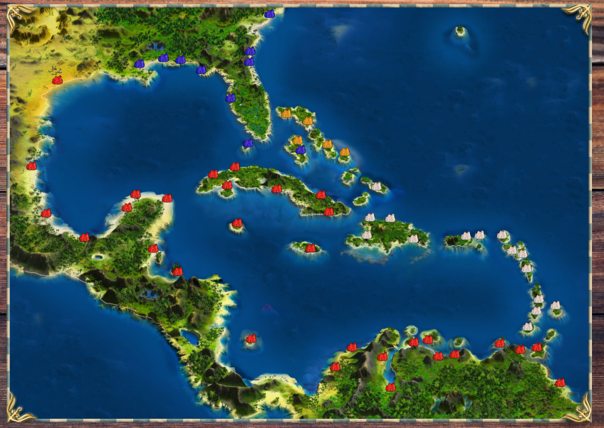
@swmackin You also have a notion of geographical resource in PR3, colonial goods like coffee, tobacco, cocoa and dye =)
Kastalia 4. juli 2024 kl. 6.21 
@Shojib
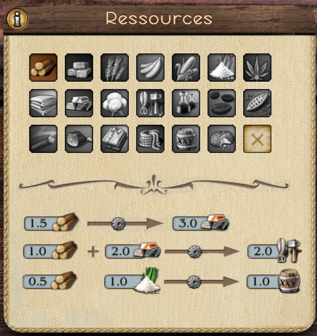
#1. Yes, exactly as it says.
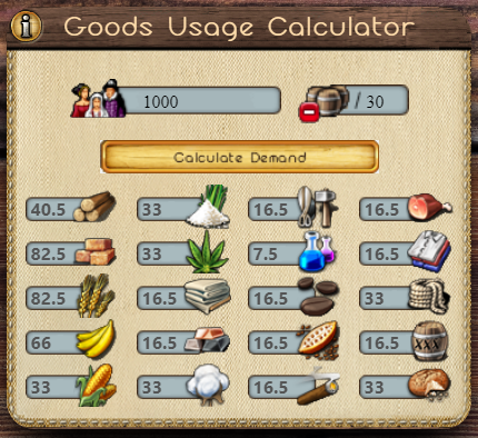
1000 people consume 82.5 wheat, 66 bananas, 33 corn, etc... per 30 days.
You can even adjust the numbers above to find out how much, for example 11700 residents consume in 23 days.
The base information is provided by the game itself that shows you the cities 10-day-consumption. These values can easily be scaled up or down with a calculator.

#3. The calculator shows the consumption of every good below